Satellite Tracking GPS AnyPlace
Our Satellite Tracker has integrated satellite transceiver, antenna and separate input/outputs. The system may stand alone or be used with an existing GPS system. It can be configured as a simple modem or integrated controller with a series of actuators and sensors.
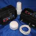
REGULAR PRICE: $1,995 SALE PRICE: $1595
$85 per month for one hour update intervals
- GPS Satellite Tracking
- GPS Satellite Applications
- IDP 600 Series Satellite Terminals
GPS ANYPLACE INMARSATE REMOTE GPS SATELLITE TRACKING SOLUTIONS
FEATURES:
Simple Integration
The GPS satellite tracking device integrates readily into large existing systems, making GPS AnyPlace OEM terminals the perfect solution for the addition of satellite tracking communication.
GPS Satellite Tracking Two-Way Communication
Affords real-time report event or schedule-driven statistics, get immediate GPS location, alter reporting intervals or check local sensor status. Monitoring remote methane pumps in coal mines is one of our recent applications.
Geo-fencing Capacity
The GPS satellite tracking system ecognizes important areas and their boundaries, and program unique reporting intervals in disparate regions.
Low Power Modes
The ability to enter Standby Mode or change the frequency of reporting gives the ability to dramatically increase battery life, which is particularly useful in remote areas where monitoring is required.
Reduced Message Latency
There are no lengthy communication delays to and from the monitored asset.
Sensor Ports (Digital and Analog I/Os)
Monitor and control emergency buttons, volumetric meters, text messaging terminals or tamper sensors. Know when the power has failed, or when equipment has been activated.
Low Power Consumption
Enjoy the benefit and cost-cutting feature of extended battery life.
GPS Jamming Detection Capability
You can be notified if a GPS signal jammer is being used to interfere with the GPS signal. The user may send message using the GPS satellite tracking system to notify the driver.
Flexible Billing Plans
Competitive pricing and many custom configurable remote monitoring applications.
Remote Programming with Customizable, Easy-to-use Interface
To minimize downtime and reduce labor and travel expenses, make use of our fast and trouble-free remote configuration changes according to your needs.
Inmarsat IsatM2M Worldwide Coverage
A worldwide solution that functions over both oceans and land, with automatic quadrant switching capacity to ensure the best satellite tracking communications.
CONTAINER AND TRAILER SATELLITE TRACKING
Intermodal containers and trailers are often under-used and on occasion lost or stolen, causing replacement expenses and delays. SkyWave satellite tracking and monitoring products not only present you up-to-the-minute location data on your assets, but also permit you to defend them from theft and operate more effectively by enjoying the following benefits:
Reduced cargo loss
Guarantee cargo safety with door, cargo, and tire pressure system sensors.
Reduced detention period
Utilize GPS location information and two-way satellite transmission to know the position of containers and ensure they are not sitting unused.
Fast retrieval of stolen or misplaced equipment
Employ GPS location information to know the current position of the asset in the occurrence of a theft.
Reduced insurance expenditure.
Reduce risk allied with stolen assets cargo or flawed goods.
Improved business and income opportunities.
Provide indispensable location information to enhance customer satisfaction and reinforce just-in-time logistics.
REFRIGERATED TRAILER GPS SATELLITE TRACKING
Shipping of temperature-sensitive merchandise, or cold chain management, is an increasingly profitable business, but progressively more refined temperature precision is necessary by regulators worldwide. The dependability of SkyWave products makes them the perfect choice for applications where miscalculation is not an option. SkyWave offers a satellite tracking and monitoring answer for the purpose of managing the temperature of precious and sensitive cargo. Benefits of deciding on a SkyWave solution include:
Reduced freight claims
Unfailingly monitor temperature of goods and guarantee that it is within the preferred range.
Remote control
Arrange your reefer from your office.
Reduced reefer fuel usage
Scrutinize run times with locations and door status.
In addition to the temperature monitoring element of the solution, you will be able to benefit from all the profits of satellite-based container tracking, including:
Reduced cargo loss
Ensure shipment safety with door, cargo, and tire pressure system sensors.
Reduced detention time
Use GPS location data and two-way satellite communication to know the location of containers and make certain they are not sitting immobile.
Fast retrieval of stolen or lost equipment
Use GPS site information to know the present location of the asset in the occurrence of a theft.
Reduced insurance expenses
Reduce risk linked with stolen assets cargo or spoiled cargo.
Increased business and income opportunities
Afford indispensable location information to enrich customer satisfaction and provide for just-in-time logistics.
HEAVY EQUIPMENT SATELLITE TRACKING
In light of the heavy investment required to own and utilize backhoes, trucks, tractors, excavators, graders and wheel loaders, it is vital to monitor heavy equipment. It is not financially viable for users to have costly machinery vanish, break down or work under their production potential. Our inexpensive terminals communicate by satellite and make available information based on usage and location for the monitoring, managing and tracking of equipment.
Remote Equipment Monitoring
In regions where there is no cellular coverage, where construction enterprises often take place, satellite communication terminals function dependably and keep communications open.
Scope of Equipment Tracking
Track and monitor all types of equipment of any type, brand or age, as well as job site buildings, gates, pumps, generators, pumps and security sensors.
Prevent Failure of Equipment and Cut Cost of Upkeep
Monitor equipment hours and mileage to ascertain proper maintenance schedules to take the guesswork out of the equation.
Improve equipment usage.
Use GPS information and two-way satellite communications to rapidly trace heavy equipment and ensure they are working at greatest efficiency.
Reduce equipment malfunction and reduced maintenance expenses
Track mileage and the number of hours that equipment is utilized. Use this data to schedule maintenance – no more guessing.
Reduce fuel use.
Receive alerts when equipment is idling for too long in order to diminish wear on equipment and fuel consumption.
Permit authorized use only.
Use geofencing, electronic timesheets and blackout hours to ensure that equipment is only being used during standard business hours at designated work sites. Obtain alarm notifications when equipment is used beyond approved areas and during evenings and weekends.
Theft security.
Distantly lock or immobilize equipment on vehicles to thwart theft.
Diminish speeding
Ensure vehicles are being operated at safe speeds outside of work areas to ensure safety of driver and safeguard vehicles. Get warning notifications when speeding is detected or an accident has occurred.
MINING INDUSTRY SATELLITE TRACKING
The mining industry spends millions of dollars in vehicles, trucks, heavy equipment and expert human resources. Ensuring their well being and security is a must to care for lives, care for investment, reduce operating costs and ensure uninterrupted operation. Because cellular-based tracking and monitoring equipment characteristically does not operate around and between mine sites, mining companies depend on satellite communications. SkyWave offers inexpensive satellite communication terminals and air-time that afford crucial GPS location and utilization information for tracking and monitoring equipment. Users of SkyWave products enjoy the following benefits:
Ensure security of drivers and other personnel.
Use GPS information and panic buttons to guarantee safety of vehicles and drivers when transporting material between sites.
Manage Fleets and Optimize Equipment Utilization
GPS data along with two-way satellite communications can be used to rapidly find heavy equipment and ensure that they are working to their full potential.
Reduce speeding
Restrict and enforce speed limits to safeguard valuable asset and ensure that precious cargo, operators and equipment are operated at safe speeds. Be warned when overspeed violations or accidents occur.
Cut back on fuel use and unnecessary idling
Obtain idling alerts when to cut fuel costs and wear and tear on equipment.
CONTAINER AND TRAILER SATELLITE TRACKING
The IDP 600 series terminals use the two-way Inmarsat IsatData Pro satellite service for remotely managing fixed and mobile assetts anywhere in the world.


SATELLITE COMMUNICATION
| Satellite Service | Two-way, IsatData Pro |
| Coverage | Global |
| From-Mobile Message | 6,400 bytes |
| To-Mobile Message | 10,000 bytes |
| Typical Latency | <15 sec, 100 bytes |
| Elevation Angle (IDP-680) | +20 to +90 degrees |
| Elevation Angle (IDP-690) | -15 to +90 degrees |
| Frequency | Rx:1525.0 to 1559.0 MHz Tx:1626.5 to 1660.5 MHz |
| EIRP (IDP-680/IDP-690) | 7.0 dBW/5.0 dBW |
GPS
| Acquisition Time | Warm: 16 sec; Cold: 36 sec |
| Accuracy | 4m (CEP) |
| Sensitivity | Acquisition: -136 dBm Tracking: -146 dBm |
EXTERNAL INTERFACES
| Inputs/Outputs | 4 - Analog or Digital In/Out |
| Serial | 1 - RS232, 1 - RS485 |
ELECTRICAL
| Input Voltage | 9 to 32V Load Dump Protection: +150V |
Power Consumption (Typical@12VDC, 22 deg. C) |
Receive: 45 mA Receive with GPS: 60 mA Transmit: 0.75 A Sleep: 100 microA |
PROGRAMMING
Lua scripting engine with core services. SKD with GUI development tools available.
| User Data Memory | 3.5 MB |
| Geofencing | 128 Polygons |
MASS
| IDP-680/IDP-690 | 460 g |
ENVIRONMENTAL
| Operating Temperature | -40 to +85 degrees C |
| Storage Temperature | -4- to +85 degrees C |
| Dust and Water Ingress | IP67 |
| Vibration | SAE J1455 (Sec 4.9, 4.2) MIL-STD-810G (Sec 514.6) |
| Shock | MIL-STD-810G (Sec 516.6) |
| Load Dump Protection | SAE J1455 (Sec 4.13) |
CERTIFICATION
| Satellite | Inmarsat Type Approved |
| Other | CE Mark, FCC, RoHS, Anatel |